TestFit Release - 3.20
Additions:
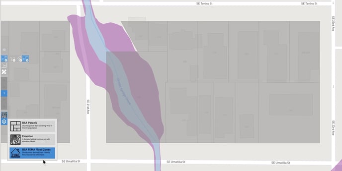
- Added FEMA Flood Zones to the new Data Layers panel for enhanced site analysis
- Added a default option for exporting geolocated DXF in WGS84 coordinates
- Set default project location
- You'll be prompted to confirm deletion of a preset
Improvements:
- Improved UX of target unit mix and area for dynamic and static unit types
- Removed blank map underlay. The streets map is now the default base map
- Improved the clarity of toolbar icons on MacOS
- New sites resulting from site slices now have unique names
Reported Issues & Bug Fixes:
- Fixed a crash that could occur when calculating deals.
- Fixed some image context menu interactions inside the unit editor.
- Fixed an issue where users with specific system configuration could have their cursor offset vertically.
- Fixed a crash that could occur when interacting with large sites.
- Fixed stairs and lifts in podium sites disappearing from garages when switched to manual stairs or lifts.
- Fixed not being able to undo/redo moving or rotating background images.
- Fixed a crash that could occur when the preferred preset was deleted and another site was placed in the same session.
- Fixed warehouse space dragging inverting when dragging spaces from older files prior to re-solving.
- Tweaked precision of warehouse area labels.
- Fixed incorrect rounding in imperial labels that don't display inches.
- Fixed incorrect labels in metric